AUSTIN (KXAN) — While the 2022 Atlantic hurricane season is off to a slower start than recent years, several variables are coming together for a rapid increase in tropical activity in mid-August.
June and July are typically quieter months in the Atlantic basin, with limited tropical storm and hurricane activity. Eighty-five percent of major hurricanes develop after Aug. 20, according to Phil Klotzbach, who works at Colorado State University and develops the Atlantic hurricane forecasts between August and October, typically the peak times for development.
By early August 2020, the Atlantic hurricane season already spawned seven tropical storms and two hurricanes. By early August 2021, we had already tallied four tropical storms and one hurricane.
This Atlantic hurricane season has only yielded three tropical storms with relatively minor impacts.

Though this seems like a quiet season to date, it is directly in-line with 30-year averages from the National Hurricane Center below, with just three named storms typical through Aug. 3.
| Number | Named systems | Hurricanes | Major Hurricanes |
|---|---|---|---|
| 1 | Jun 20 | Aug 11 | Sep 1 |
| 2 | Jul 17 | Aug 26 | Sep 19 |
| 3 | Aug 3 | Sep 7 | Oct 28 |
| 4 | Aug 15 | Sep 16 | – |
| 5 | Aug 22 | Sep 28 | – |
| 6 | Aug 29 | Oct 15 | – |
| 7 | Sep 3 | Nov 15 | – |
| 8 | Sep 9 | – | – |
| 9 | Sep 16 | – | – |
| 10 | Sep 22 | – | – |
| 11 | Oct 2 | – | – |
| 12 | Oct 11 | – | – |
| 13 | Oct 25 | – | – |
| 14 | Nov 19 | – | – |
Atlantic hurricane season ramps up beginning in August due to a variety of factors including warmer ocean waters, less Saharan dust in the atmosphere, and more disturbances marching across the ocean from Africa which act as “seedlings” for tropical storms.
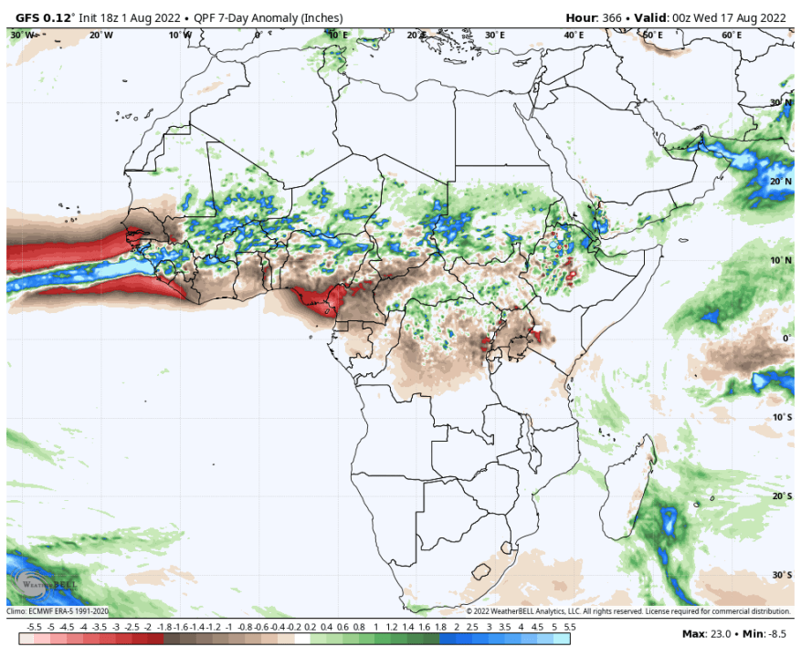
We are tracking an expected increase in disturbances rolling off the coast of Africa during the middle of August. These tropical waves can act as embryos for tropical storm development as they trek westward across the Atlantic. As Joe Bastardi of Weatherbell.com writes, “the wave train is going to start running,” with wetter than normal weather expected across the interior of Africa where these seedlings are born.
The final variable expected to lead to an increase in tropical activity in mid-August is the Madden-Julian Oscillation, or MJO. We can think of the MJO as a large-scale area of rising or sinking air which can either enhance or suppress storm development.
As a storm-supporting area of rising motion moves over the Atlantic mid to late-August, large-scale rising motion will replace large-scale sinking, making conditions more favorable overall for tropical development. A setup like this led to a hurricane outbreak at the end of August 2020.

While all of these variables will lead to an increase in tropical activity in the Atlantic, it will not come immediately. Long-range forecast models are suggesting the current lull in activity lasts through Aug. 12, with an increase coming between Aug. 12-20.

While we expect a sharp uptick in hurricane activity, it is impossible to forecast where the storms may go until they form. Forecasters at CSU diagnose a higher than normal 59% chance of a Texas hurricane strike this year (average: 36%), and a 28% chance of a major hurricane strike (average: 16%).
Source: Fox 8 News Channel
Be First to Comment