The Moravians of Bethlehem gathered for their Sunday evening music service. A joyous occasion at any time, this gathering was likely tinged with some sadness as well. Fifteen men were set to leave the Moravian settlement the next morning to build the church’s southern home on the Wachovia tract in North Carolina.
Carefully chosen for their skills, the group included several farmers, a cook, a washer, a baker, a gardener, a tailor, a shoe-maker, a surgeon, and a nurse. Men with carpentry, mill-wright, cooper, turner, and soldiering skills. One was noted as a “man whom all animals love,” another as “skillful in many things and willing in all.”
They left before sunrise the next day, Oct. 8, 1753, and walked for three days to catch up with the wagon that had left some days before them. They had to stay an extra night as they waited for the wagon to be made three inches narrower so it could manage the coming trail.
The 500-mile journey was expected to take about six weeks. The first leg from Bethlehem to Harris’ Ferry (Harrisburg), past Carl Isle (Carlisle) and heading south toward Friedrichstown, Virginia (Winchester) was through settled territory with roads that were passably maintained.
They crossed the Potomac River into Virginia on the 17th and reached Friedrichstown the next day.
Two hundred miles down in 10 days. The next 300 would take 31 days.
Tens of thousands of Europeans, mostly Scots and Germans, made this or similar treks to the North Carolina backcountry from settlements in Pennsylvania and Maryland from the late 1740s until the Revolutionary War. Some, such as the vaunted Vogler family, came from as far away as Maine and Massachusetts to Salem.
They packed what possessions they had and what provisions they could afford on stubborn mules and towering Conestoga wagons and started walking. They were in search of a variety of things; cheaper land, less government interference, adventure.
Some, like the Morvians, were methodical in their preparations. Some were less prepared for the challenges and dangers.
Once they left settled areas they traveled ancient paths used by the Native Americans for trade, diplomacy, warfare, and hunting. They cobbled together the easiest grades and river crossings to create roads, roads we still use today.
The Bethlehem crew came down what many today know as the Great Wagon Road which turned east near present-day Roanoke, Virginia, and entered North Carolina near Danville before heading to Salem. They called it the Upper Road. Others knew it as the Valley Road. Today we know it as Interstate 81 and Route 220.
Another important path to this region began at the falls on the Appomattox River where Petersburg, Virginia, is today. The English established Fort Henry at the head of an existing route they called the Indian Trading Path and along which they conducted very lucrative trade with the tribes as far south as Charlotte and eventually into Georgia.
This path essentially mirrors I-85.
Salisbury sits where the Wagon Road and the Indian Trading Path intersected by an easy ford on the Town Creek where traders regularly set up impromptu markets in good weather.
Smaller paths became local roads across the country. Here in Surry County Route 89 followed such trails. Early settlers to this area noted what they called “The Warrior Trail” and what others call the New River and Southern Trail sits on the western border of the county.
The best-known and most-used of the old native trails in Surry County became the Hollow Road or the Main Wagon Road that connected the area with the Moravian settlements around Salem. The Moravian community diaries of 1762 note, “February 20. This week a wagon road has been opened from the Hollow to Bethania.”
A great deal of business was done up and down that road selling apples, furniture, mill stones, and tobacco. Quite a number of Surry County families migrated northward from Salem including the Wolfes, Spainhours, and the Voglers.
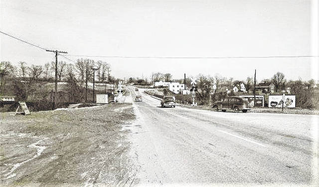
As our ability to change the geography to suit our needs grew more powerful and bridges became less expensive to build, highways were built around towns and cities. This picture shows Rockford Street looking east up the hill where Northern Regional Hospital will eventually stand. The car to the right is sitting on the Route 52 bypass still under construction in January 1953 just months after the tragic accident that took Robert Lee Duncan’s life and injured four other family members. The Road Closed sign can be seen to the left. Regulations about warnings were put in place to avoid such tragedies in the future. Note the water tower in the distance on top of the hill, not yet painted with the famous silhouette of Sheriff Taylor and his son walking to the fishing hole.
https://www.mtairynews.com/wp-content/uploads/2020/04/web1_52-601-Intersection-Construction-.jpgAs our ability to change the geography to suit our needs grew more powerful and bridges became less expensive to build, highways were built around towns and cities. This picture shows Rockford Street looking east up the hill where Northern Regional Hospital will eventually stand. The car to the right is sitting on the Route 52 bypass still under construction in January 1953 just months after the tragic accident that took Robert Lee Duncan’s life and injured four other family members. The Road Closed sign can be seen to the left. Regulations about warnings were put in place to avoid such tragedies in the future. Note the water tower in the distance on top of the hill, not yet painted with the famous silhouette of Sheriff Taylor and his son walking to the fishing hole. Mount Airy Museum of Regional History
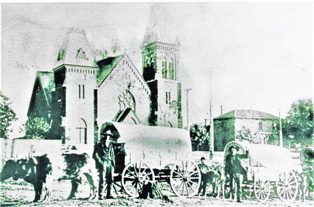
Mount Airy’s Main Street, Old Rt 52, grew on an existing Native American trail that ran from the Occaneechi Path (also known as the Indian Trading Path) in today’s Winston-Salem north crossing the New River and connecting with other trails that went through the Cumberland Gap and the Shenandoah Valley. It became the principal route farmers in Carroll County, Virginia, used to get their produce and other goods to the lucrative Winston markets. Greenberry Easter (right) and William Joseph Easter (left) are shown with the wagons of apples they’d hauled from Carroll County orchards to Winston where they are shown in the early 1900s.
https://www.mtairynews.com/wp-content/uploads/2020/04/web1_Easters-Church-.jpgMount Airy’s Main Street, Old Rt 52, grew on an existing Native American trail that ran from the Occaneechi Path (also known as the Indian Trading Path) in today’s Winston-Salem north crossing the New River and connecting with other trails that went through the Cumberland Gap and the Shenandoah Valley. It became the principal route farmers in Carroll County, Virginia, used to get their produce and other goods to the lucrative Winston markets. Greenberry Easter (right) and William Joseph Easter (left) are shown with the wagons of apples they’d hauled from Carroll County orchards to Winston where they are shown in the early 1900s. Mount Airy Museum of Regional History
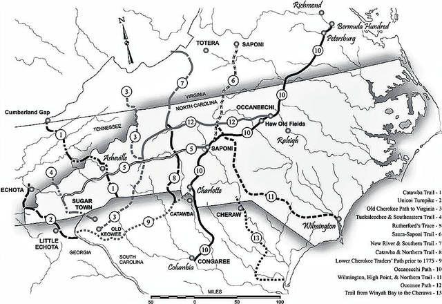
No one can perfectly map ancient trails as development and overgrowth from disuse obliterate or hide the evidence but this map from the state Office of Archives & History shows the approximate routes established by Native Americans for trade, war, and migration. These same paths were used by Europeans as they traded with the native population and moved into the region. Many remain as local roads or, in some cases, interstates. The Saura-Saponi Trail, 6 on this map, roughly traces Route 29 from north of Charlottesville, Virginia, through Danville, Virginia, and joining with the Occaneechi Path (now I-85) near Greensboro before terminating in the Native town, Saponi just outside of Salisbury. (Map by Mark Anderson Moore.)
https://www.mtairynews.com/wp-content/uploads/2020/04/web1_Trail-Map-USE.jpgNo one can perfectly map ancient trails as development and overgrowth from disuse obliterate or hide the evidence but this map from the state Office of Archives & History shows the approximate routes established by Native Americans for trade, war, and migration. These same paths were used by Europeans as they traded with the native population and moved into the region. Many remain as local roads or, in some cases, interstates. The Saura-Saponi Trail, 6 on this map, roughly traces Route 29 from north of Charlottesville, Virginia, through Danville, Virginia, and joining with the Occaneechi Path (now I-85) near Greensboro before terminating in the Native town, Saponi just outside of Salisbury. (Map by Mark Anderson Moore.) Mount Airy Museum of Regional History
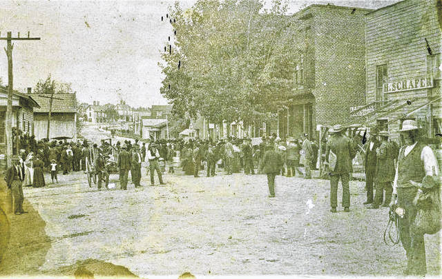
The Native American trail that ran through Mount Airy into Virginia was designated a Post Road by the US Congress at least as early as 1801. It became a regular fixture on the stage and postal routes, allowing commerce to grow. The first house in the distance, built by Rawley “Ruff” Haymore, sits where BB&T Bank sits today at the corner of Rawley Street. The front eve of Trinity Episcopal, built in 1896, can be seen beyond the tree in the center of the picture. H. Schafer Dry Goods, in the foreground, moved a block down the street in February 1897 dating this picture to the summer or fall of 1896.
https://www.mtairynews.com/wp-content/uploads/2020/04/web1_Main-St-USE-.jpgThe Native American trail that ran through Mount Airy into Virginia was designated a Post Road by the US Congress at least as early as 1801. It became a regular fixture on the stage and postal routes, allowing commerce to grow. The first house in the distance, built by Rawley “Ruff” Haymore, sits where BB&T Bank sits today at the corner of Rawley Street. The front eve of Trinity Episcopal, built in 1896, can be seen beyond the tree in the center of the picture. H. Schafer Dry Goods, in the foreground, moved a block down the street in February 1897 dating this picture to the summer or fall of 1896. Mount Airy Museum of Regional History
Many trails still used as highways today
By Kate Rauhauser-Smith
Kate Rauhauser-Smith is the visitor services manager for the Mount Airy Museum of Regional History with 22 years in journalism before joining the museum staff. She and her family moved to Mount Airy in 2005 from Pennsylvania where she was also involved with museums and history tours. She can be reached at KRSmith@NorthCarolinaMuseum.org or by calling 336-786-4478 x228